Maricá (Portuguese pronunciation: [maɾiˈka]) is a municipality located in the Brazilian state of Rio de Janeiro. It is located in the Greater Niterói region (or Metropolitan East), bordering Itaboraí, São Gonçalo, Rio Bonito, Niterói, Saquarema and Tanguá.
The municipal territory extends over 361.572 km² and is divided into four districts: Maricá (headquarters), Ponta Negra, Inoã and Itaipuaçu.
The municipality can be accessed via RJ-106 (Amaral Peixoto Highway), which connects the municipality to the cities of Niterói, São Gonçalo and Saquarema, or via RJ-114, which connects the municipality of Itaboraí and the RJ-104 and BR-101 highways.
The municipality of Maricá is also known for its rural properties – small farms and large ranches – many of which are rich in historical content. The train also passed through the city – even today, there are remnants of that time, such as stations, tracks, a tunnel and a bridge in the Inoã neighborhood, with the inscription Estrada de Ferro Maricá.
The city has an airport, which does not operate regular flights, only offshore operations, known as Maricá Airport, located in the urban center.
Geography
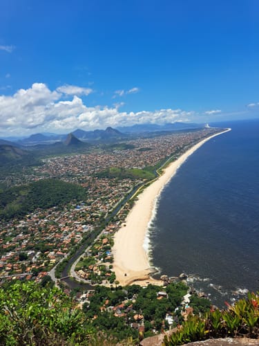
Maricá is a city of the Rio de Janeiro Metropolitan Area, located on the coast of the Atlantic Ocean and 25 miles away from the city of Rio de Janeiro.
The municipality contains part of the 2,400 hectares (5,900 acres) Serra da Tiririca State Park, created in 1991.
Population
Area
Its area is 362,571 km2.
Territorial organization
Maricá is administratively divided into 50 bairros (neighborhoods) and 4 distritos (districts).
Transportation
Maricá has an airport, the Maricá Airport. Maricá is served by the roads BR-116 and RJ-104.
Economy
Maricá has received many royalties from the Brazilian energy company Petrobras, because of the Campos Basin and Santos Basin oil field.
Climate
References
- Conhecendo a Cidade de Maricá - [2]
/i.s3.glbimg.com/v1/AUTH_d72fd4bf0af74c0c89d27a5a226dbbf8/internal_photos/bs/2023/z/R/4naGJnRfaDXU9ftB0HAA/8-marica.jpg)